
Quiet Skies: Navigating the Remainder of the 2026 Hurricane Season with WeatherOptics and Trimble
An Operational Briefing on Revised Forecasts and Inland Risks for the 2026 Hurricane Season
The climatological peak of Atlantic 2026 Hurricane Season is here and the horizon remains surprisingly clear. Early September typically signals a surge in tropical activity but current atmospheric conditions have created a significant dearth of activity compared to normal.
A below-normal hurricane season does not warrant a lapse in vigilance. Late-season activity in the Gulf remains possible, and the Midwest and Northeast are forecast to stay highly susceptible to flood impacts from any remnant tropical activity.
A "Well Below Normal" Projection
The National Hurricane Center (NHC) and Colorado State University (CSU) have both revised their forecasts for an already below-normal activity further downward. We now project a well-below-normal hurricane season. The updated figures reflect an environment that is increasingly hostile to storm organization.
Metric | 1991-2020 Average | NHC Forecast | CSU Forecast |
Named Storms | 14 | 7–13 | 9 |
Hurricanes | 7 | 2–6 | 4 |
Major Hurricanes (Cat 3+) | 3 | 0–2 | 1 |

El Niño and Wind Shear
The primary driver behind this suppressed activity is the continued strengthening of El Niño. This climate pattern is generating perpetual vertical wind shear across the Atlantic Basin. Wind shear is a critical deterrent for tropical cyclones as it effectively rips apart the circulation of developing storms before they can intensify.
This hostile environment is particularly dominant in the Main Development Region (MDR)—the stretch of ocean between the Caribbean and Africa where 80% of major hurricanes typically form. One month-averaged wind shear here is the strongest on record, according to CSU meteorologist Philip Klotzbach. Consequently, development in this region is expected to remain minimal for the foreseeable future.
Subseasonal models like the CFS currently hint that one-month averaged shear anomalies may weaken beginning in early October, particularly in the northern half of the MDR. This suggests there may be windows during which time wind shear could relax enough to support tropical cyclone formation towards the end of the peak of hurricane season.

Weak African Monsoons
Hurricanes don’t form spontaneously. They originate from disorganized low pressure systems called ‘tropical waves’ that usually manifest as broken clusters of showers and thunderstorms drifting westward with the trade winds across the Atlantic.
Most tropical waves stem from monsoon activity in West Africa. Monsoonal rainfall this year has been below normal due to El Niño. With less frequent and less intense rainfall, there are fewer and weaker tropical waves reaching the open Atlantic. Weaker tropical waves are less likely to grow into hurricanes.
Regional Focus: The Gulf
While the Atlantic as a whole is expected to generally remain quiet, the most likely window for tropical development for the remainder of the season is concentrated in the Gulf.
In an average year, 2.2 named storms form in the Gulf, accounting for roughly 15% of all Atlantic systems. Many of these Gulf storms originate from tropical waves that travel from the Main Development Region, meaning they are not entirely independent of conditions elsewhere in the basin. However, entirely “home grown” storms do occur—and in fact, three of the five named storms this season developed that very way.
Looking ahead, the local environment in the Gulf appears increasingly conducive to additional formation in this manner. Wind shear there is currently much lower than in the Main Development Region, and we generally expect this pattern to persist through the fall. At the same time, sea surface temperatures in the Gulf are running slightly above normal. Taken together, these conditions would be moderately favorable for tropical cyclone development—provided, of course, that any disturbance actually manages to reach the area.
Most ‘home-grown’ disturbances that form entirely in the Gulf originate from frontal systems that stall around the Gulf coast. These tend to be more common in the fall so peak activity this season is more likely to occur in late September through mid-October than in the typical late August to mid-September window.
Due to the stubborn high pressure system that is forecast to continue dominating the western and central US, steering winds will favor storm tracks that make landfall in Texas or Florida, including the panhandle.
Impact Zones: Texas and Florida remain most favored for direct impacts
Reduced Odds: Even with this localized risk, the overall odds of a significant landfall remain lower than historical averages for this time of year
The Hidden Hazard: Inland Flood Susceptibility
Hurricanes may be rated by their top wind speeds but the primary danger from any tropical cyclone is flooding rainfall. Even weak tropical systems or their remnants can pose life-threatening risks.
Significant flooding has already occurred this season across parts of Louisiana and Mississippi due to moisture related to Tropical Storm Arthur in mid-June. Some areas experienced more than two feet of rain. Cottonport, LA received 29” of rain in 24 hours, setting a new state record. Significant flooding was unleashed, particularly in St. Tammany Parish, prompting hundreds of water rescues. Arthur only had its name for 13 hours.
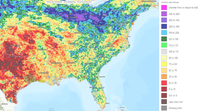
We expect the stagnant weather pattern that has been in place most of the summer featuring strong high pressure in the Intermountain West and series of low pressure systems cascading around it into the Eastern US to persist into the early fall. This pattern has contributed to regular heavy deluges, including this week, mainly targeting the Mid-Mississippi Valley, Ohio Valley, Central Appalachians and northern Mid-Atlantic. Much of this area has experienced 2-3x the normal amount of rainfall this summer.
With future tropical activity expected to favor the Gulf Coast, tropical remnants would be favored to impact these areas that as of the first week of September still had saturated soils and above-normal streamflows.
It has been drier than normal along the Gulf Coast but major flood impacts will still be possible with future tropical activity. The flooding caused by Arthur earlier this season occurred when the region was facing a drought. Tropical systems don’t need a name to wreck havoc. Emergency managers and logistics providers should remain vigilant regarding post-tropical flood impacts, even in a "quiet" season like this one.
Predicting Hurricane Impact with Trimble + WeatherOptics
Trimble integrates WeatherOptics’ AI-driven, hyperlocal weather intelligence directly into its fleet management ecosystem, including CoPilot navigation, routing, and back-office Weather Console, to transform raw weather forecasts into predictive risk management.
Core Predictive Intelligence Capabilities
Rather than issuing broad, reactive alerts, WeatherOptics processes government data, road topology, vehicle data, and historical impacts to deliver predictive 0–10 risk scores updated every 15 minutes up to 7 days in advance at a 3 km grid granularity:
Flood & Water Risk: Evaluates specific localized flood risks and severity along exact travel corridors.
Tipping/Rollover Index: Calculates real-time rollover danger based on hyperlocal wind speed, direction, and vehicle heading.
Speed Reduction & Business Disruption: Forecasts percentage travel delays (improving ETA accuracy up to 60%) and synthesizes overall operational impact, including road closures and infrastructure damage.
Platform Integration & Workflows
Platform | Target User | Key Actions & Functionality |
CoPilot (In-Cab) | Drivers | Provides pre-trip route weather summaries, customizable audible and visual hazard alerts, and automatic risk recalculations if a driver goes off-route. |
Weather Console (Back-Office) | Dispatchers & Safety Managers | Filters active trips by risk level (Moderate to Critical), issues 15-minute email notifications, cross-references GPS pings with radar layers, and tracks historic speed reductions. |
Severe Weather & Hurricane Season Preparedness
During extreme weather events like hurricanes and snowstoms—where high-impact scores (7–10) signify severe danger, infrastructure damage, and extended road closures—Trimble Weather Intelligence allows fleets to shift from reactive guessing to proactive mitigation:
Strategic Route Optimization and Dispatching: Using the Trimble Weather Console, dispatchers run side-by-side path comparisons against 7-day predictive weather and road forecasts to front-load critical shipments, delay dispatches into landfall zones, or re-route assets away from storm surges.
In-Flight Safety: Real-time driver alerts warn of high-wind rollover risks or severe flooding miles ahead, giving drivers ample time to adjust Hours of Service (HOS) breaks and safely pull off the road before reaching dangerous areas.
Supply Chain Communication: Precise speed-reduction modeling gives back-office teams data-backed visibility into storm delays, enabling accurate, advance notification to shippers and customers.
Enterprise-Wide Integration: Powered by PC*Miler Web Services APIs, commercial-grade weather intelligence seamlessly embeds directly into any enterprise TMS or dispatch environment to protect drivers and preserve profitability.
See It in Action
Learn more about WeatherOptics: https://www.weatheroptics.co/
Learn more about Trimble Weather Intelligence:


Comments